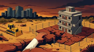
In Khanamet, Hyderabad, an entire apartment complex was built on government-assigned land. Real estate firms claimed four acres. A construction company set up an industrial plant. Another individual deployed private security guards on the remaining four acres. The encroachment was worth an estimated ₹1,200 crore.
The document trail showed it was government land all along. But nobody checked for years. When HYDRAA finally reclaimed the land in April 2026, the encroachment had been running for over a decade.
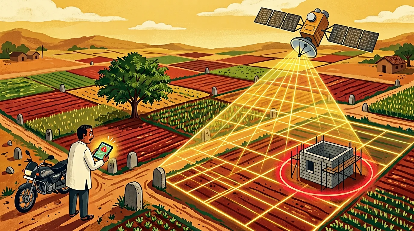
Now imagine a different version of this story. One where a satellite photographs Survey No. 55 every month. An algorithm notices new construction activity on land classified as “assigned” in the revenue database. An alert fires to the District Collector’s office within days - not years.
That system is not science fiction. Parts of it already exist.
The Scale of the Problem
HYDRAA alone reclaimed over 87 acres worth ₹10,804 crore in Hyderabad in just the first two months of 2026. That is one city, one agency, in 57 days.
Nationally, the numbers are staggering. Government land across India spans forest land, assigned land, ceiling-surplus land, endowment land, defence land, and railway land - held by Union ministries, state governments, and public sector enterprises. Nobody knows the total. And nobody knows how much of it is encroached. The Comptroller and Auditor General (CAG) has repeatedly flagged that state governments do not maintain databases of government land, and that data on encroachment is not available at district and tahsil levels.
The traditional method of detecting encroachment is a revenue inspector physically visiting land parcels. Given the volume of government land across India, this is like asking a handful of guards to patrol an entire continent. Encroachment happens in the gaps between visits - and those gaps can be years long.
What Already Works
Bhubaneswar: India’s First Satellite-Monitored City
Odisha’s capital became the first city in India to use satellite imagery for systematic land protection. The Bhubaneswar Land Use Intelligence System (BLUIS), built by the Odisha Space Applications Centre (ORSAC) and Vassar Labs, uses Planet Labs’ SkySat imagery to monitor government land on a monthly cadence.
The system works in three steps:
- Acquire: Download high-resolution (50cm per pixel) satellite imagery of mapped government parcels
- Classify: An algorithm categorises land features - buildings, vegetation, bare soil, construction materials
- Detect: Compare the current image to the previous month’s image and flag changes
When new construction appears on government land, an alert goes to officials for field verification. The key insight: monthly monitoring means encroachment is caught within weeks, not years.
Defence Estates: 62 Cantonments Under Watch
India’s defence land is among the most encroached in the country - prime urban plots held by the military since the British era, surrounded by expanding cities.
The Directorate General Defence Estates (DGDE) addressed this by developing an AI-based detection system with the Bhabha Atomic Research Centre (BARC) using ISRO’s Cartosat-3 imagery (25cm resolution - sharp enough to see individual rooms of a building).
In a single exercise across 62 cantonments, the system detected 1,133 unauthorised changes. Of these, action had already been taken in 570 cases. For the remaining 563, cantonment boards initiated legal proceedings. The system essentially caught what human patrols had missed and held officials accountable for inaction on what they already knew about.
Greater Noida: ISRO + Municipal Government
The Greater Noida Industrial Development Authority (GNIDA) partnered with ISRO’s National Remote Sensing Centre (NRSC) to build an AI-powered monitoring system. High-resolution satellite images are analysed by AI models trained to detect variations in land patterns. When changes do not align with approved layouts, the system flags them.
This is particularly relevant because Greater Noida - like Hyderabad’s IT corridor - has seen explosive real estate growth on the back of government land allocations. The same conditions that enabled the Khanamet encroachment.
How the Technology Works
The core principle is deceptively simple: take a picture of the land now, compare it to a picture from last month, and flag what changed.
Step 1: Baseline Mapping
Every government land parcel is mapped - survey number, boundaries, classification (assigned, forest, government, endowment), and current state (vacant, agricultural, built-up). This baseline comes from existing land records (ROR 1B, cadastral maps) overlaid on satellite imagery.
Step 2: Regular Monitoring
Satellites photograph the land at fixed intervals. The frequency depends on the resolution and cost trade-off:
| Satellite | Resolution | Revisit | Cost |
|---|---|---|---|
| Sentinel-2 (ESA) | 10m | 5 days | Free |
| IRS (ISRO) | 1-5m | Variable | Government access |
| Cartosat-3 (ISRO) | 25cm | On demand | Government use |
| SkySat (Planet) | 50cm | Daily possible | Commercial |
For detecting large-scale encroachment (a construction site, an RCC plant, deforestation), 1-5 metre resolution is sufficient. For catching individual boundary violations, sub-metre imagery is needed.
Step 3: AI Change Detection
Machine learning algorithms compare images pixel by pixel, but with intelligence. They are trained to distinguish between:
- Seasonal changes (crops growing and being harvested) - normal
- Construction activity (new structures, cleared ground, materials) - flagged
- Boundary changes (new fencing, walls, roads) - flagged
- Land use changes (agricultural to commercial) - flagged
The algorithms learn from thousands of labelled examples. A new building on government land looks different from a farmer adding a bund to their field.
Step 4: Alert and Verification
When the system detects a suspicious change, it generates an alert with:
- The survey number and location
- Before-and-after satellite images
- The land classification from revenue records
- A risk score based on the type and scale of change
A revenue official or enforcement agency verifies the alert on the ground. If confirmed, action is initiated immediately - not a decade later.
What Is Missing: The Gaps Between Detection and Action
The technology works. The three Indian systems described above prove it. But technology alone does not solve the problem. The Khanamet case illustrates three gaps that no satellite can fix:
Gap 1: Land Records Must Be Accurate First
Satellite monitoring compares what is on the ground to what should be on the ground. That “should be” comes from land records - the ROR 1B, the cadastral maps, the land classification databases.
If those records are wrong - and in India, they frequently are - the system breaks. Telangana’s own Bhu Bharati portal (which replaced Dharani) inherited data errors from the old system. If a government land parcel is incorrectly recorded as private in the database, the satellite system will not flag construction on it as encroachment.
The baseline has to be right before the monitoring works.
Gap 2: Institutional Coordination
In the Khanamet case, the revenue department (District Collector), the registration department (Sub-Registrar), the municipal authority (GHMC), and the planning authority (HMDA) all had different pieces of the puzzle. The District Collector knew it was government land. The Sub-Registrar was told to block registrations. GHMC apparently issued building permissions (or did not - the record is unclear). HMDA should have flagged the layout.
A satellite system that sends alerts to the revenue department does nothing if the municipal authority continues to issue building permissions. The alert needs to reach every agency that can enable or prevent encroachment.
Gap 3: Enforcement Speed
The Khanamet timeline: assigned land (pre-1977) → first prohibition notification (2013) → HYDRAA reclamation (2026). Even if a satellite had detected the encroachment in 2008, would the government have acted in 2008? The history suggests not.
Detection without enforcement is surveillance without consequence. The DGDE system found this: of 1,133 detected encroachments, action had already been taken on only 570. The remaining 563 were known encroachments that officials had not acted on. The satellite did not reveal new problems - it revealed the enforcement gap.
A Wishlist: What a Complete System Would Look Like
Here is what a technology-driven approach to protecting India’s government land could look like, combining what already works with what is technically feasible:
1. A National Government Land Registry
A single, authoritative digital database of every government land parcel in India - survey number, classification, boundaries, responsible agency. This does not exist today. The technology for it (GIS databases, satellite-verified boundaries) is mature. The challenge is institutional: getting thousands of revenue offices across states to contribute and maintain accurate data.
SVAMITVA, the central government’s drone-based property mapping scheme, is surveying rural India village by village. Extending this to government land parcels would create the baseline needed for satellite monitoring.
2. Automated Monthly Satellite Monitoring
Using ISRO’s own satellite constellation (Cartosat, Resourcesat, and the upcoming Nisar mission), every mapped government land parcel is photographed monthly. AI change detection algorithms - already proven in Bhubaneswar, Greater Noida, and the 62 cantonments - flag anomalies.
At current ISRO capacity, monitoring priority parcels (urban, high-value, near development corridors) is immediately feasible. Full national coverage would require expanding the satellite tasking schedule, but India’s growing constellation makes this achievable within years, not decades.
3. Cross-linked Alerts
When the satellite system flags a change:
- The District Collector receives an encroachment alert
- The Sub-Registrar receives a prohibition update blocking any new registrations
- The Municipal Authority receives a stop-work order preventing building permissions
- The RERA Authority receives a flag preventing project registrations
No single agency can solve the problem. All of them need to know simultaneously.
4. A Public Monitoring Layer
Property buyers should not have to trust the government to catch encroachment. A public-facing layer of the monitoring system - visible on Bhuvan or Bhu Bharati - would let anyone check whether a parcel has been flagged.
Imagine searching for a survey number on Bhu Bharati and seeing:
- Current satellite image (dated within the last month)
- Land classification (assigned, government, private)
- Prohibited status under 22-A
- Change detection history (any flags raised in the last 5 years)
That is the equivalent of a credit score for land - and it would have saved every flat buyer in Khanamet’s Swapna Vihar.
5. Crowdsourced Ground Truth
Satellites cannot see everything. Tree cover can hide structures. Low-rise encroachments may not register at 1-5 metre resolution. And some encroachment starts with fencing or occupation that looks identical to legitimate farming from orbit.
A reporting mechanism - a mobile app where citizens can photograph and geolocate suspected encroachment - would complement satellite monitoring. HYDRAA already receives public tips. Formalising this into a verified reporting system, where reports are matched against the satellite monitoring layer, would create a faster feedback loop.
What Property Owners Can Do Today
While waiting for the government to deploy comprehensive satellite monitoring, property owners - especially those with land in high-growth corridors - can take steps themselves:
Monitor your coordinates. Free tools like Google Earth Pro let you view historical satellite imagery of any location. Compare images across years to spot changes on your land or adjacent parcels. We have written before about how digital land records can change without notice - satellite imagery is the independent cross-check.
Check Bhuvan. ISRO’s geoportal (bhuvan.nrsc.gov.in) provides satellite imagery layers for India. It is not real-time, but it is useful for verifying the current state of a parcel.
Set up alerts. Bhu Bharati (Telangana), Meebhoomi (AP), and other state portals allow you to search land records by survey number. Check your records periodically for any changes in classification, ownership, or encumbrances.
Document the current state. Photograph your land boundaries. Get a fresh FMB (Field Measurement Book) sketch. If your land is vacant, the documented state today becomes your evidence if encroachment happens tomorrow.
Before buying, verify everything. The Khanamet case showed that the documents were clear all along. The ROR 1B, the prohibited list, and the revenue records all pointed to government land. The buyers who got trapped were the ones who skipped these checks or relied on the builder’s assurance.
The Bottom Line
The technology to detect and prevent land encroachment at scale exists today. India is already using it in pockets - Bhubaneswar, Greater Noida, 62 cantonments. ISRO has the satellites. AI change detection is proven. Digital land records, however imperfect, are improving.
What is missing is not technology. It is the decision to deploy it systematically, the institutional coordination to act on alerts, and the political will to enforce against encroachers - even when they are well-connected real estate firms rather than roadside squatters.
In Khanamet, the documents told the story for decades. A satellite watching that land would have told it even louder. The question was never whether the encroachment was detectable. It was whether anyone was looking.
India cannot afford to keep not looking. Not when 66% of civil cases are property disputes, not when government land worth thousands of crores is quietly disappearing under construction sheds and apartment complexes, and not when the technology to stop it is already here.
Assetly helps property owners organise, verify, and monitor their property documents digitally - because the best time to catch a problem is before it becomes a ₹1,200 crore dispute.